 Huygens’ Descent Imager Spectral Radiometer (DISR) team has now produced mosaic images of the probe’s descent to Titan’s surface. These were created by combining images taken by Huygens as it rotated on its axis, the first image showing the view from approximately 20 kilometers altitude. The photos were taken in groups of three as the probe descended through the atmosphere last January.
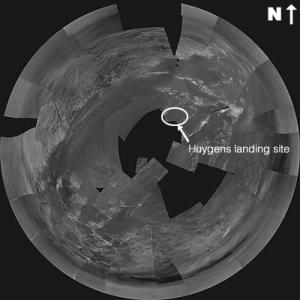
Image: (click to see enlargement): This stereographic projection of DISR images from ESA’s Huygens probe combines 60 images in 31 triplets, projected from a height of 3000 metres above the black ‘lakebed’ surface. The bright area to the north (top of the image) and west is higher than the rest of the terrain, and covered in dark lines that appear to be drainage channels. Credits: ESA/NASA/JPL/University of Arizona.
The stereoscopic image shown above is intriguing because of what appears to be going on in the north and west (top and top left of the image). Be sure to click on the image to see it in higher resolution. According to an ESA news release, this area is covered in dark lines that give the appearance of drainage channels:
These lead down to what appears to be a shoreline with river deltas and sand bars…The current interpretation of these lines is that they are cut by flowing liquid methane. Some of them may have been produced by precipitation run-off, producing a dense network of narrow channels and features with sharp branching angles. Some others may have been produced by sapping or sub-surface flows, giving shape to short stubby channels that join at 90 degree angles.
And later:
The bright shapes to the north-east and east look to be ridges of ice gravel that are slightly higher than the flats around them, and the probe landing is believed to be just south-west of the semi-circular shape. The light and dark areas to the south are still of unknown nature.
 The other image is a ‘gnomonic’ projection (the method makes the surface appear to be flat — again, click to enlarge). It was assembled from images taken at roughly 800 meters, as the landing site is approaching, and shows dark channels some 30 to 40 meters wide.
Image: This gnomonic projection of DISR images from ESA’s Huygens probe combines 17 image triplets, projected from an altitude of 800 metres. The area covered is approximately 1300 metres across (north at the top of the image). The smallest visible objects visible are less than five metres across, and the dark channels are 30-40 metres wide. Credits: ESA/NASA/JPL/University of Arizona.