If you’ve seen the Sierra Nevadas, you know what Bob Brown is talking about when he likens the mountain range found on Titan to those beautiful peaks in the western United States. Brown (University of Arizona) is team leader of the Cassini visual and infrared mapping spectrometer. Cassini was able to resolve features down to 400 meters (1300 feet) on its October 25 flyby. And suddenly we have a mountain range, dunes, and something resembling a volcanic flow under Titan’s inscrutable atmosphere.
Fascinatingly, at the top of the ridges are deposits of a white material that may be ethane snow or some other form of organic substance. Here’s Cassini scientist Larry Soderblom (USGS) on the organics:
“There seem to be layers and layers of various coats of organic ‘paint’ on top of each other on these mountain tops, almost like a painter laying the background on a canvas. Some of this organic gunk falls out of the atmosphere as rain, dust, or smog onto the valley floors and mountain tops, which are coated with dark spots that appear to be brushed, washed, scoured and moved around the surface.”
The Titan news is getting wide media coverage, so I’ll simply point you to this link to JPL’s news release on the subject. It’s interesting to me how quickly we get used to human operations in truly exotic places. After we’ve seen spectacular images like the backlit rings of Saturn, we tend to go about our daily routine forgetting that the vehicle is still out there and working. And then Cassini bobs back into the news with yet another spectacular image or paradigm-shifting dataset and we’re reminded just what an outstanding job our robotic explorers continue to perform.
A friend asked today how it was possible that we could be discovering entire mountain ranges for the first time on a world that had undergone so many surveys by Cassini. For the answer, examine the image below. These are composites made from radar, visual and infrared mapping spectrometer data. Take a close look and ponder what you’re seeing.
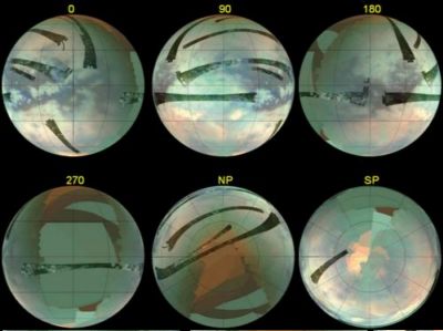
Image: This set of composite images was constructed from the best Cassini radar data and visual and infrared mapping spectrometer data obtained from all the Titan flybys up to the most recent flyby on Oct 25 (T20). The globe to the upper right is centered on 0 degrees longitude, and each of the other globes is labeled as to which longitude appears at the center of the disk. The two rightmost images in the bottom row are of the north and south poles of Titan, respectively. Credit: NASA/JPL/University of Arizona.
What stands out in the image is the sheer extent of what, if it were on Earth, we would call terra incognita. We see some detail from radar surveys, to be sure, and then the much more highly defined visual and infrared mapping spectrometer swathes. But you can see how little of the satellite’s surface is covered by the latter. In contrast to places like Triton, Titan seems more and more familiar, but in reality we’re only beginning to plumb its secrets. Ah for a Mars-style rover on that distant surface!


Hi Paul
The more we learn the more I wish NASA would launch a one-way manned flight to Titan like in Stephen Baxter’s book, “Titan”, which is now kind of dated thanks to real results from Cassini and Huygens. But it’s still an intriguing concept – lash some drop tanks to a Shuttle for braking propellant, plus some Topaz reactors, and habitat and so forth, then use all the Saturn Vs sitting around museums plus the other two Shuttle orbiters (sans wings and TPS and crew) to launch enough fuel and rocket motors up to it to send it into a Cassini-like trajectory around the inner planets and onwards to Saturn.
Might take 7 years, but it’s a journey that seems worth it. Lots of problems with Baxter’s presentation I discovered – he merely replayed Cassini’s mission itinerary, thus not actually using a computed trajectory. Fair enough. Short cuts make sense in some fictions. Still a cool idea as new configurations of planets appear all the time to provide a launch window, but some can take 12 years or so. Ouch!
I’ve mucked around with this idea for a while, reading up on Apollo and Saturn Vs, playing with Cassini orbits and so on. NASA has never really managed getting value for money out of its old technology – look at the fully functional “Skylab” given to the Smithsonian. Could’ve been the core of an International Space Station in the late 1970s – they have enough Saturn Vs left to launch it.
And the whole Apollo/Saturn experience was never built on – one option for launching the Shuttle was to have used a Saturn IC first stage to boost the Orbiter and the External fuel tank. Deemed “too expensive” but it would’ve gotten cheaper once a reusable Saturn IC was developed. And we all know how the Shuttle made spaceflight so much cheaper… *cough* *cough*
Ok. Late night gripe (+10 GMT where I live.)
Adam
Yes, point well taken! The Shuttle could have used quite a bit of innovative thinking re available technologies, and I like your Saturn first stage idea, since pushing that component into active duty would have forced reusable designs. Well, we go with what we’ve got, but couple all this with a lack of mission objectives and the Shuttle is clearly a vehicle whose time is long gone.
Haven’t read that particular Baxter story, but I always enjoy him.
To explore Titan via rover we’ll need real autonomous AI style systems to drive it over totally unexpected terrain. Despite recent improvements in that field demonstrated in the Mohave last year, we’re still a ways from fielding a rover that could guide itself. The lightspeed round trip travel time to Titan is a couple hours.
The 2nd problem is power source. Solar is out. Nuclear, probably the hated RTG is the only viable option.
I’d prefer a Titan balloon explorer to any other mission. That would be more surprising and need I say entertaining to the public and space fans than say yet another mission to Venus. Won’t likely see it in my lifetime. Too ‘risky’ for NASA mgmnt and too expensive.
Titan expert Ralph Lorenz advocates using a helicopter
as the best means to explore the alien moon’s surface:
http://www.lpi.usra.edu/meetings/outerplanets2001/pdf/4003.pdf
Hi Larry
Ralph’s always full of ideas about Titan – his work is my first source for just about everything I know about the place. Oddly enough he and Baxter described a Titan around a red-giant Sun fit for life about the same time, but without cross-flow of ideas. Seemed the time was right. Lorenz suggests that once the Sun hits about 12 times its current luminosity Titan will be warmed to ~ 200 K so warm enough for ammonia/water oceans. Because the Sun’s UV output will be much lower the haze will clear and the methane greenhouse effect will come into full effect.
A helicopter could also be a good way to get around for explorers – the lower gravity and denser atmosphere make the power requirements for slow flight quite low indeed – personal flying platforms would have much lower power requirements or much higher range. I like the idea of using fan-propelled “flying chairs” with a para-glider wing. If the temperature issues can be handled that is – 95 K is CHILLY. Dirigibles should also be able to climb to incredible heights because the rate of change of air density is so slow. Good way to explore the super-rotational flow in the high stratosphere.
Interesting concept for a Titan vehicular power plant:
On Titan, you might fill your fuel tanks with oxidant (oxygen or chlorine), whilst the atmosphere might provide the combustible methane fuel through normal aspiration! That just seems wrong somehow. ;)
I think I might submit this one to the NIAC. What do you think?
On further evaluation, it seems the atmospheric methane content would be too low. This might only work in the atmosphere during a Titanian rainstorm (methane clouds).
However I could see a future wherein a couple of spacesuited figures, tooling around in a Titanian vehicle, are complaining about the cost of oxidizers these days…
It seems Titan might be more suited for heavy industrialization than most solar-system bodies. The abundance of reactants is comparable to our own abundant oxidizer. I wonder if ready-for-use oxidizers might exist in underground pools/caches? I suppose they can be extracted from locally obtained materials, but this might be technically difficult. At least you wouldn’t have to worry about smogging up the atmosphere!
Going on the helicopter theme, here is one way that future
explorers might get around Titan:
http://dreamsofspace.nfshost.com/1953lauriespaceannual.htm
Title: On the feasibility of a new frontiers class Saturn probe mission
Authors: Balint, Tibor S.
Keywords: Saturn probes microwave radiometry
New Frontiers
Issue Date: 27-Jun-2006
Publisher: Pasadena, CA : Jet Propulsion Laboratory, National Aeronautics and Space Administration, 2006.
Citation: 4th International Planetary Probe Workshop, Pasadena, California, June 27-30, 2006.
URI: http://hdl.handle.net/2014/39758
http://trs-new.jpl.nasa.gov/dspace/handle/2014/39758