The Jet Propulsion Laboratory is offering this map of planned imaging coverage for the Huygens probe as it descends toward Titan’s surface on Friday.
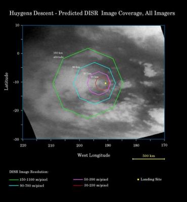
Image: This map illustrates the planned imaging coverage for the Descent Imager/Spectral Radiometer, onboard the European Space Agency’s Huygens probe during the probe’s descent toward Titan’s surface on Jan. 14, 2005. The Descent Imager/Spectral Radiometer is one of two NASA instruments on the probe. The colored lines delineate regions that will be imaged at different resolutions as the probe descends. On each map, the site where Huygens is predicted to land is marked with a yellow dot. This area is in a boundary between dark and bright regions. Credit: NASA/JPL/Space Science Institute.
Click here for further information on the map and background about the descent. We are less than two days away from Huygens’ entry into Titan’s atmosphere, and Centauri Dreams seconds the JPL intro to this image: Go Huygens!